
Co-Written by Peter Wang and Dominic Marziali
Staff Writers
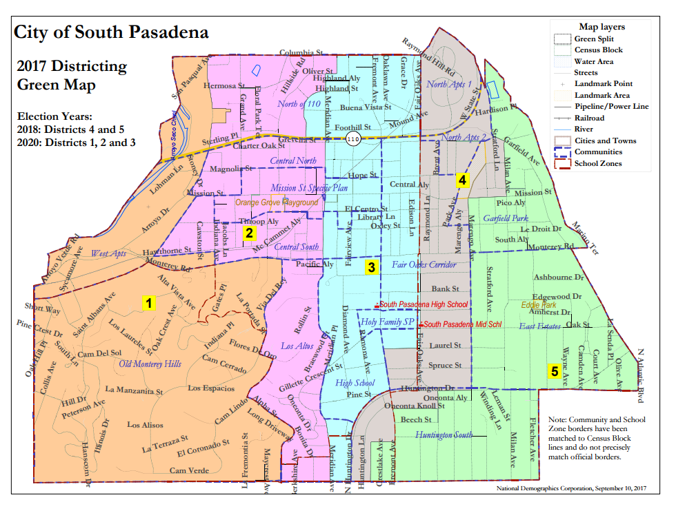
District maps attached at the conclusion of the article
Courtesy of the City of South Pasadena
The South Pasadena City Clerk’s department hosted a community workshop to present and receive input regarding the proposed voting district maps Saturday, September 16th. Chief City Clerk Anthony Mejia and interim City Manager Elaine Aguilar explained the rationale and criteria behind the maps, and answered many questions from community members.
The maps showed the different ways in which South Pasadena will be divided into districts. The residents of each district will only vote for candidates who live in that district, and each councilmember represents the concerns and interests of their district. Using community workshops, public hearings, and meetings, the city provided opportunities for input from residents. Mr. Mejia encouraged residents to get involved with the process.
During the public comments session, several residents voiced their concerns regarding the city’s current transition process, in addition to the strengths or weaknesses of each map. The city is currently transitioning to a district-based election system in response to attorney Kevin Shenkman’s allegation of a voting rights violation.
Many community members were divided on the issue’s solution, unlike previous public hearings in which residents’ opinions were mostly unified. While certain residents supported unifying the Old Monterey Hills and Los Altos as constituents of a single councilmember, others felt that a two-district hill separation would encourage cooperation between the council and stronger representation. While most residents did not address benefits of the new election districts, one resident favored the new system because it will potentially boost renters’ participation in local government.
Several residents representing the Central South neighborhood—bounded by El Centro to Monterey and Pasadena to Fremont—expressed great opposition to the maps, as each of the four maps will split up the region. They argued that the area’s unity should be preserved due to unique traffic issues and its school proximity.
Another resident concern addressed the city split-caused possibility of disparities in the issues that are important to each councilmember, as a councilmember is only responsible for representing the interests of his/her own district. Under an at-large system, a councilmember must represent the interests of the entire city regardless of where they personally reside.
The city must adopt a district-based voting system by October 17th, the final day of the CVRA-stated litigation-free grace period after Shenkman sent his allegation letter. In accordance with this time constraint, the city council will select a final map and vote on adopting voting districts during the October 4th city council meeting.
The city also criticized Shenkman’s motive for his voting rights litigation campaign. According to the city, his primary reason for sending out accusation letters is to gain personal wealth, as he has accumulated over $9 million from attorney’s fee reimbursements.
In an upcoming city council meeting on September 20th, the public will be able to suggest edits of the maps to the city council. After September 20th, there will be no opportunity for further public comments. A final version of the district map will be selected during the October 4th meeting; the council will also vote to formally adopt a district-based election system on the same day.


Attached below is the interactive online version of the district maps:
http://www.arcgis.com/apps/View/index.html?appid=98f2e41aa1f54c8aaf2ed15b2feb269b
and the demographic data per map:
http://www.ci.south-pasadena.ca.us/modules/showdocument.aspx?documentid=13677

I am very impressed with the quality of this article. Mr. Marziali did a fantastic job summarizing this complex issue and the sentiment of the residents at the Community Workshop.